
 |
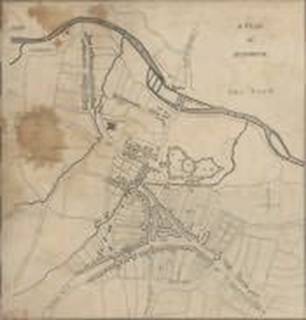
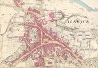
In this 1796 map of Alnwick, there is no detail to the south of the town. Green Batt is called “Back Row”. Virtually all of the buildings lie within the boundaries of the medieval town, and front onto the central triangle or the three main roads. The burgage plots behind the buildings are still empty. The only other road in this part of town is called “Stoney Hill Road”. |
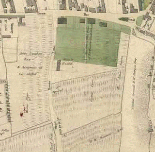 |
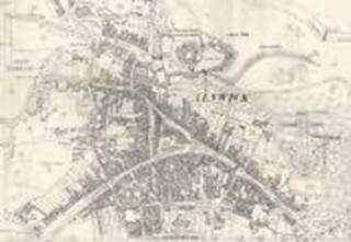
Until the 19th century was under way, most development in Alnwick was happening within the boundaries of the old town. Mainly this was achieved by building at the tail end of the medieval burgage plots, along the roads that ringed the town along the original line of the old town wall. So Woods map of 1827 shows few buildings outside Green Batt (at top of image). Beyond this he land was still agricultural, although some country houses such as Croft House, Belle Vue and Clive House were starting to appear, surrounded by open fields. Here the fields below Green Batt are shaded green to show that they belong to the duke. The land to the west of Hope House Lane was called Wester Piece, and the land south of Prudhoe Street and east of Hope house Lane was called Easter Piece. Neither Lisburn Street nor Prudhoe street exists on the original map, but the routes have been added after the map was printed (not entirely on the line that was actually built). Hope House Lane is here shown, along the line of Percy Street and Percy Terrace, but there are very few buildings. There are three houses in the positions of 1 Prudhoe Street, The Haining and Laburnum Cottage. There are no other houses on the lane. There is also a lane shown along the line of Argyll Terrace, and a field boundary along the access to Percy Villas. The rest is fields. |
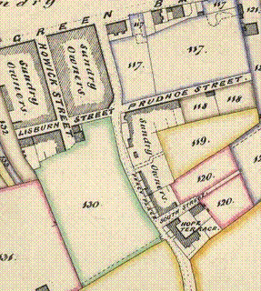 |
The Tithe Award map of 1846 show little detail of buildings, but it does show some outlines on the east side of the road, which here is called “Percy Place”. By now Lisburn Street, Prudhoe Street and South Street are also shown, but Howick Street is incomplete, and Argyll Terrace still seems to be a path along the edge of a field. By the middle of the 19th century there was less land left for development within the old town, and more development was happening along the turnpike roads. Examples from elsewhere in Alnwick include Clive Terrace along the turnpike road through Rothbury to Hexham, and Belvedere Terrace along the Great North Road from Newcastle. Here, the Howick Street Development is starting to appear on what was Wester Field, to the west of Percy Street. The map also shows how only one line of houses was built at the north end of Easter Field (east of the road) while at the south end of Easter field there was a deeper plot, so South Street was used to allow access to more houses than could have been fronted onto the road. |
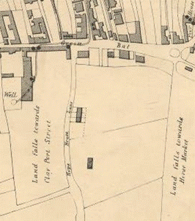 |
The Cholera map of 1849 is of a later date, but it was created from the same base as Woods map of 1827, so it does not show all the houses that existed in 1849. It does show the fields more clearly than Woods map (above), but not the line of Lisburn street or Prudhoe Street. There is also another building shown here which looks as though it must be off South Street, and presumably dates from 1827 or before – but Im not sure which it is. In reality, by 1849 there should be more houses in Percy Terrace, but none of them are shown. Significantly, though, there are no deaths shown from cholera in Percy Terrace. The nearest, marked by black spots, were in Green Batt and St Michaels Lane. Either people living in Percy Terrace were lucky, or they must have been using a safe water supply. |
 |
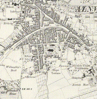
There is a detailed 25 inch Ordnance Survey map from the 1860s, which shows individual buildings, but we do not yet have a copy of the sheet which shows the bulk of Percy Terrace. Around this time the name of the road does not seem to have been settled. In different places it is referred to as Percy Street, and Percy Place. By now most of the area around Percy Terrace is developed – either with housing or with various new institutions, such as The Mechaincs Institute (1831), St Pauls Church (1848), the Railway Station (1849), the Corn Exchange (1862), and a Police Station in Green Batt. |
 |
There is a detailed 25 inch Ordnance Survey map of 1897, which shows individual buildings, but we do not yet have a copy of the sheet which shows the bulk of Percy Terrace |
 |
The 6 inch Ordnance Survey map of 1897 shows that most of Percy Terrace was in place towards the end of the 19th century. At this time Prudhoe Street only ran to the end of the churchyard, and Lisburn Street not much further than Howick Street. |
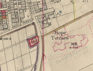 |
We do not yet have the whole of Percy Terrace shown on the land valuation map of 1910, but what is there can be seen in some detail. The school opened in 1903, but seems to have been added to this 1910 map, so the survey must have been earlier. By this time they seem to have settled on Percy Terrace as the name of the road. |
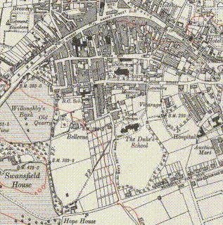 |
The six inch Ordnance Survey map of 1920 shows little change from 20 years earlier in Percy Terrace, although the Dukes School has now been built. Lisburn Street and Prudhoe Street are complete, King Street is in place, and Swansfield Park Road is in place, with houses starting to appear. |
##DEFAULT##